PART TWO
THE GENESIS OF THE
DANUBIAN HUNGARIANS
THE NEOLITHIC AND BRONZE AGE HUNGARIANS
1. Implantation of the Higher Civilization into the Danubian basin
1. "Higher Civilization" is the comprehensive term for the major material and spiritual innovations made by man during the Neolithic and Bronze Ages. It signifies a settled way of life characterized by food-production through agricultural activity and stock-breeding. In view of the scarcity or total absence of contemporary written evidences, this early period of human life is usually reconstructed with the help of its material remains, whose study is archaeology. In the following account, we frequently use another scientific term as well, which is "historical Hungary". It means the unitary area of Central Europe which is bounded on three sides — north, east and southeast — by the Carpathian mountain ranges, in the south by the Low Danube and the river Sava, and to the west by the first elevations of the Alps (Fig. 1). After its principal mountain-range and principal river, it is also known as the "Carpathian Land" and "Middle Danube basin", or, more precisely, the "Carpatho-Danubian area". For over a thousand years (until 1920), this area formed a single political entity, the Kingdom of Hungary.
'Historical Hungary' is rich in archaeological remains. The most significant finds which were made there until the mid-fifties, have been described by Edith B. Thomas in her German language Archaeologische Funde in Ungarn (P 125). Since that time the soil has yielded so much valuable new material that this basic work needed to be completed. The two most important complementary publications are from Nándor Kalicz: Archaeology of the Neolithic and Bronze Ages in Hungary, in Hungarian (P 074) and Neolithic Finds at Méhtelek (also in H., P 075). The international connections of the Hungarian New Stone Age have first been recognized by Gordon Childe in his fundamental work The Danube in Prehistory (P 031), while the great role the Middle Danube area played in spreading Higher Civilization westward, has been summarized by Jacquetta Hawkes in several of her comprehensive studies (P 064; P 065 and P 066). The excellent maps of H. T. Waterbolk (P 134), showing the diffusion of food-production-methods, especially into Europe, are indispensable even for the student of Hungarian archaeology. These publications may give the reader a perfectly clear idea and up-to-date information about the various archaeological aspects of early Hungary.
2. Neolithic agriculture found very favourable conditions in Hungary, where it flourished rapidly, especially on the great Central Plain and where mighty rivers — the Danube, Tisza, Maros and Körös — assure abundant year-round water supply. Moreover, Hungary has extensive loess soil, which is easily handled, even with primitive implements, because it consists of very minute, windblown particles of high capillarity. In addition to agriculture, breeding of domestic animals (cattle, sheep, pigs, goats and dogs) played an important part in early food-production. In this regard, a long-horned, Oriental cattle-race deserves special mention because their descendants can be admired even today in the Hortobágy National Park near Debrecen. Manufacturing of pottery, spinning and weaving were the most important industrial activities. Large vases were made for storage purposes, smaller ones for every-day use, while ceramic statuettes and other artistic products satisfied the needs of the Church. Timbered houses above the ground and small, self-sufficient villages, as well as incipient writing completed the Neolithic way of life in early Hungary.
There are over 200 known sites that bear testimony of the material remains of Hungarian Higher Civilization. All were located on virgin soil, i.e. they form the oldest layer in excavated sites. This is an important fact because it indicates that there is no trace of previous more primitive food-production in the Carpatho-Danubian area. There, the Neolithic appears unprecedented and suddenly, in a fully developed form. Consequently, this was not a phenomenon of local origin but was caused by immigrants coming from another region.
The Neolithic Age began in Hungary in the fifth millenium B.C. It first appeared along the Körös river, in the central part of the Great Plain, hence its name: Körös culture. It remained the dominant neolithic group for a period of over a thousand and five hundred years, until about 3200 B.C. and has left lasting marks upon all subsequent, similar Danubian cultures. The most sensational remains of the Körös culture have come to light at Méhtelek in 1973. This tiny village is in the Upper Szamos valley in an isolated location: about 200 km away from the centre of this culture. This unique location is explained by the presence of enormous quantities of obsidian, a very precious industrial material during that epoch, for whose exploitation a whole colony was set up. In order to fathom how important this exploitation was, it is significant that the five pits which were open so far by archaeologists yielded several thousand raw lumps and finished wares, as compared with barely a hundred which were previously inventoried for all of Hungary. Another surprise: nearly sixty Venus-statuettes were dug out in that area, as compared with a total of forty that were previously discovered. No other such rich obsidian centre has ever been found elsewhere in Europe (P 096 and P 075).
During the era of the Körös culture, Transdanubia and Upper Hungary were covered with another neolithic culture, the so-called Danube-I, radiocarbon-dated c. 4430 B.C. From its decorated pottery, it is also known as Linear Pottery Culture, or Bandkeramik and its preference for loess soil is particularly visible. A third major Hungarian neolithic culture was the Banatian culture (c. 3200 B.C.-2300 B.C.), which included the Transylvanian Olt basin (Erősd) and formed a link with the more extensive Tripolje culture in Eastern Europe, famous for its painted pottery. The fourth was the Tisza culture (c. 2800 B.C.-c. 2500 B.C.) which produced the finest and most valuable pottery. The fifth or last one was the Péceli culture (c. 2100 B.C.-1900 B.C.). It already covered the whole territory of Hungary and the Vienna and Moravian basins as well.
Hungary's five neolithic cultures cover an uninterrupted period of over two millenia and show a surprisingly high degree of uniformity over the whole area. They have successfully incorporated almost all the material and spiritual innovations of the world's first Higher Civilization which flourished in the Ancient Near East, and became a secondary centre of diffusion for the benefit of all central and north-western Europe.(39)
3. Metal-using cultures appeared in Hungary in the middle of the IIIrd millenium. The first period, from c. 2500 B.C., is characterized by an abundant use of copper and gold; the second, from c. 1900 to 800 B.C. by its preference for bronze. Hungarian archaeologists therefore like to speak of separate Copper and Bronze Ages, yet the two periods constitute but a single one, bronze being an alloy of 90% copper with 10% tin or antimony. That Hungary was capable of developing a brilliant metallurgy before any other European country is due to the rich copper mines in her mountains, and the abundance of alluvial gold deposited in the tributary streams of the Tisza.
A good illustration of Hungary's richness in precious metals at that time is the gold plate of Mojgrád in Szilágy county (Fig. 25). It weighs 750 gr and reflects a neolithic pattern, insofar as only the eyes and the nose are represented on it, while the mouth is omitted. The plate was, in all probability, a sacred object whose brilliant face represented the Sungod. It may have been the identification plate of a high priest when officiating. The most distinctive Hungarian product was, however, the hammer-axe, with a disc for the butt (Fig. 26). It was a native form, derived from an earlier copper shaft-hole axe, this last being the derivative of a stone axe. The metallurgic centres of Hungary were so productive that they literally inundated contemporary markets with their daggers, swords, spears, arrow-heads, goblets and bracelets. The proper evaluation of Hungary's metallurgical activities, both in the Copper and Bronze Ages, can be derived from Prof. Dawson's remarks, who summed up his findings thus: "It is clear that during this period Hungary was the centre of a brilliant development of culture which, from the artistic point of view, surpassed anything that existed elsewhere in Central Europe... The splendid Hungarian swords and axes, often ornamented with elaborate spiral decorations, are perhaps the finest specimens of European bronze work, and supplied the models for similar types of the Nordic Bronze Age" (P 039 p. 326).
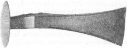
Fig. 26. Hungarian hammer-axe with disc for a butt. It was in great demand in the Bronze Age.
4. As already pointed out, the neolithic way of life was not indigenous to Hungary, but came from an outside geographic area. According to our present knowledge, this can but be the Ancient Near-East, where all the wild ancestors of domesticated plants and animals were present and where food-production was achieved at an earlier date. The accuracy of this fact has subsequently been proven with comparative archaeology. Scholars of that study discovered, indeed, a strong affinity, both in form and style, between the earliest Hungarian artifacts and their Oriental counterparts. It was, in particular, noticed that the Hungarian axes strongly resembled those found in the Royal Cemetery of Ur, that Transylvanian sickles originated from Mesopotamian forms and that the oldest Hungarian pottery was similar to that found in the oldest layers of the ruins of Ur, Kish, Assur and other ancient cities of Mesopotamia. Concordances found in the Nile valley were just as convincing: long-horned Egyptian cattle, native of the Delta, survives 3000 years later in the Hungarian National Park of Hortobágy. In the same park, specimens can be seen of a special breed of sheep with twisted horns, spread horizontally at an angle of about 120 degrees, now called Racka. In ancient Egypt these sheep were sacred to the God Khum, the ram-headed divinity. This race has since become extinct there. In the grave of King Hasekhe-mui of the Second Dynasty (c. 2703 B.C.-2686 B.C.) a gold object was found, whose material may originally have come from Hungary. It is indeed covered with a thin layer of antimony (Sb) and tellurium (Te) which occur only in the gold of the Carpathian basin. Another proof of the ancient Egypto-Hungarian connections is the splendid jar found in Egyed, in Sopron county. The God Thot recording the sins of the deceased is depicted on its sides.
The civilization of the ancient Near-East embraced not only Mesopotamia and Egypt, which we just mentioned, but Syria and Anatolia as well, with which countries the Carpatho-Danubian region was already directly connected. Such contacts were numerous, as shown by two enormous rapiers, over 90 cm in length, which were found in the heart of Transylvania. They correspond exactly to the so-called Shardina-sword from Palestine (now in the British Museum). There were also bracelets and beads made from Mediterranean shells. Moreover, certain idols of Hungary are the exact duplicates of those found on the Island of Cyprus (Élet és Tudomány, 1974 no. 38). The Boghaz-Kői (Hittite) pottery designs from the XIVth century B.C. had their duplicates in the Maros valley in Hungary. Hungarian gourd-shaped vessels were like Cappadocian specimens, while Hungarian bronze jars found in Ózd near Miskolc, and elsewhere, were similar to their Trojan prototypes from around 2100 B.C. And the gold plate from Mojgrád shows a close resemblance to a similar figure from Troy II. Thus Higher Civilization from the Orient reached Hungary overland, through the Balkan corridor formed by the narrow valleys of the Vardar and Morava rivers. This route was in use for over two thousand years and its importance only began to decline after the fall of Troy II, c. 1200 B.C. The route has been practically closed since the Vllth century B.C.
In spite of the close links with its Oriental model, the Higher Civilization of Hungary was not a simple copy of it, since it could boast of several original features. One of the most important of these was dry-farming. As a matter of fact, the Hungarian rivers, unlike those of Mesopotamia and Egypt, had no regular floods. Therefore,-production by irrigation was not practised to a great extent here. Instead, the Danubian farmers selected the windblown, porous loess soil for cultivation, after having cleared it of its small growth. Later, with the appearance of metallic tools and other more efficacious agricultural implements (plough), it was possible to include heavier but better clay soil as well into the cultivated area. Thanks to this and to similar inventions, Danubian farmers were highly superior in production to those on the Balkans, including Greece. The adaptation to European environment was a significant innovation; it opened the door for Hungarian farmers to spread out westwards, into Central and Western Europe.
Besides the Danubian Neolithic, early Europe possessed two other neolithic cultures: the Tripolje or Black Earth culture, with its painted pottery, and the Lake Dwelling culture in Switzerland. The first one unfolded in Eastern Europe, between the Dnieper and the Low Danube. Its exact origin is still unknown, although it is certain that it owed its existence to the same source that gave rise to the Danubian neolithic civilization. The Tripolje culture disappeared, however, quite soon after the so-called Battle-axe people appeared, whereas the Lake Dwelling, on account of its very special conditions, could not be introduced elsewhere. As a result, the Hungarian or Danubian neolithic culture remained without rival in central and western Europe. This privileged situation explains its lasting influence over vast areas for about two thousand years. The westward extension of the Danubian civilization proceeded along the Danube and its interconnections on the one hand, and along the Vistula and Oder on the other. In the words of Prof. G. Childe: "for over two thousand years it (the Danube) formed the channel by which the influence of the Higher Civilization of the Eastern Mediterranean basin, including Anatolia and Syria, was transmitted to the barbarian North and even to distant Britain" (P 073 p. 413).(40)
2. The advent of the first sedentary population
1. In the two thousand years immediately preceding the Neolithic Age from c. 5500 B.C. to 3500 B.C., neither the Middle Danube basin nor Central Europe in general had any permanent population (P 134). This fact excludes the possibility that the Danubian cultural and technical upswing might have been the result of borrowing through commercial contacts, no one being present at the receiving end. It is therefore generally assumed that the introduction of the Higher Civilization in the Carpatho-Danubian area was the work of actual colonization by immigrant farmers and metal workers.
In fact, the first colonists began to reach Hungary immediately after the climatic change, in the so-called Subboreal Period. During that period the average rainfall was less than today, and the yearly temperature was 7°C above the present average. With the increasing dryness, dense forests thinned out, marshes shrank to a smaller size or even disappeared, more room becoming available for ethnic movements. The Vardar-Morava corridor, which cuts the Balkans right in half, opened up and funnelled migrant groups of cultivators and herdsmen in an ever increasing number into Hungary. The bulk of migrants came from the western parts of the Ancient Near East: from Syria and Anatolia, although the original point of departure of many of them was Mesopotamia and Egypt.
The described ethnic movement can best be followed with the study of old place-names, the 'toponymy'. Its usefulness for detecting ethnic movements stems from the general human behaviour that immigrants, as soon as they settle in a free place, give names to the surrounding geographic features. When correctly interpreted, these names may disclose the geographic origin of the first colonists, the time of their arrival, the state of their civilization, their language, their ethnic appurtenance, and even the area of colonization in the new land. For all these advantages, toponymy has become one of the most productive subsidiary branches of history; it may open "dazzling perspectives," — as the French linguist Albert Dauzat expressed it (P 037 p. 70). The historical interpretation of place-names needs, however, a very careful analysis, because they were themselves subject to phonetical distortions, following the various sound-shifts, the vowel harmony and the shifting of accent. Therefore the first task of the toponymist consists of elucidating the oldest spelling of a given place-name, which usually conserves the original meaning of the name most clearly. In this respect, however, the effective contribution of Hungarian linguists to our knowledge in this particular field was, until recently inadequate, due to their rather conservative frame of mind (cf. P 009 p. 56 f.). Under these circumstances, this author had to supply the basic documentation for this chapter.
2. A first group of Hungarian place-names, throwing light upon the geographic origin of her inhabitants, includes such names that are identical to those of their previous dwelling places. The immigrants, indeed, make use of the same vocabulary in christening, to which they were accustomed. This habit is verifiable even in our days, and it explains why we have so many 'London', 'Paris', 'Athens' and other European names in America, duplicating the toponymy of their former country. In a similar way, there is, in Hungary, a series of place-names which are repetitive to those of Anatolia, Syria, Mesopotamia and Egypt. Let us quote a few such names. First, the name of Troy (anc. Turia), in western Anatolia, also occurs in Hungary as Torja and Tiirje. The name of Arzawa in southern Anatolia is duplicated in southern Hungary as Orsova. The Phoenician city of Arad has its Hungarian namesake in the great city of Arad. Two Hungarian villages called Haláp (located in the counties of Zala and Bihar) correspond to the important city of Haleb (today: Aleppo). The Syrian Bukk valley has its namesake in Hungary in the Bükk mountain and Bükk town. The Palestinian Pilis country or Pilis-Ta is identical to the Hungarian Pilis name, used as a county, mountain and village name. The Palestinian river Kishont also re-appears in Hungary in the same form as Kishont, a county-name.
The list of similar place-names continues with Egyptian and Mesopotamian names. Ancien Egypt had a border-land called Zala or Sala. It was a marshy region in the north-eastern Delta, where a fortress was located to guard the military road to Syria. The same name occurs in Hungary, in both forms as Zala and Sala, a county which formerly resembled a marshy border-land in its southern parts. Egypt's Nitra is duplicated in Hungary with Nyitra (anc. Nitra) as a county, city and river name. The southern part of the Sinai peninsula, under Egyptian rule since the unification of the "Two Lands" in c. 3200 B.C., was known as Bakon; its Hungarian homonym is also Bakony, a forested area to the northwest of the Balaton Lake. Even Egyptian king-names were used as Hungarian place-names, so that Tata, Papa and Menes are Tata, Pápa, Ménes, Ménfő, Ménfa.
There are several duplicates of the Mesopotamian river names in Hungary. E. g. Kherka and Sajur, both tributaries of the Tigris, appear in Hungary as Kerka and Sajó. The Mesopotamian native name of the land beyond the river Euphrates was Burattu; its Hungarian equivalent is Berettyó. The Hungarian Karas, Körös and Krassó correspond to the Mesopotamian Karasu. Finally, northern Mesopotamia was called Subaru and Subartu to which the Hungarian Szabar village-names in the Vas, Györ and Nógrád counties correspond, as well as Sabaria, the capital city of former Pannónia. Such parallels are not merely coincidental, since certain Arab historical sources mention that the Hungarians were formerly called by the ethnic name Sabartoi-Asphaloi.
A second series of Near-Eastern — Hungarian common place-names are those that contain the name of an Oriental pagan divinity. We have already mentioned some of them in a previous chapter dealing with mythology. So it suffices here to remind the reader that the most frequent divine names in question are the Sungod's various names, such as 'lord' {Ur, Ra); 'Eye God' {Szemes); 'Sky God' (Ég-Ur); 'The Enthroned God' (Szék-Ur); 'Heavenly Horse' {Égi Ló). The second popular pagan divinity whose name is used in Hungarian place-names is Bál (Baal), the Syrian Fire God. Places bearing the name of this god are most frequent in the southern half of the country, in the Balaton Lake area and in Transylvania. This regrouping suggests that the Baal-worshipping colonists may have arrived after the Sun-worshippers. The third most frequently occurring divinity name was that of the God Thot, protector of arts and letters in Egypt. Finally, a third series of Hungarian place-names of Near Eastern origin are those which are formed with Oriental ethnic or tribal names. These are e.g. Hetés or Hetis, meaning 'Seven Ancestors' and Hetény, recalling the descendants of the Hittites, who were led by exactly seven (Héth) princes. Another Oriental ethnic name is Pilis, which was already mentioned. These three series of specific Hungarian place-names — duplicating names, divine names and ethnic names — prove that ancient Hungary received the greater part of its first permanent population from the Ancient Near East during the Neolithic and Bronze Ages. The first wave was made up mostly of agriculturists coming into the Carpatho-Danubian area through the Balkan corridor of the Vardar-Morava valleys.
3. Having clarified the geographic origin of Hungary's first sedentary population, our attention will be focussed next upon their territorial expansion in the land. Our research in this connection is based partly upon the three series of place-names just discussed, and partly upon place-names which include one of the following six Old Hungarian formative suffixes denoting dwelling places: 1. Ta (variant: Da) meaning 'Land'; 2. Hon (var. On, An, Ony) 'Home'; 3. Szék (var. Szeg, Szik) 'Residence'; 4. Kö (var. Ka, Ke, Kev) literally 'Stone', also 'Village'; 5. Pis (>Biz, Viz) 'Water'; and 6. Mat (var. Ma, Mad, Mata) 'Field'. Proof of the great antiquity of these six formative suffixes is the fact that today they are no longer used for name-giving purposes, that they are common in the entire Finno-Ugric language group and that the words in question were in continuous use in the Ancient Orient since the IIIrd millenium B.C. at least.
We begin our illustration with the word Ta. It occurs in the following Near Eastern place-names: Pilis-Ta, Heti-Ta, Cre-Ta, Kushi-Ta, Subar-Tu, Urar-Tu, etc. In European Hungary the following names are formed with the same element: Ágo-Ta, Bago-Ta, Bak-Ta, Bó-Ta, Bucsu-Ta, Cinko-Ta, Csaj-Ta, Csász-Ta, Galán-Ta, Ino-Ta, Kádár-Ta, Kalo-Ta, Laj-Ta, Panko-Ta, Pilis-Ta, Pusz-Ta; further: Ab-Da, An-Da, Or-Da, Ra-Da, Tor-Da, Var-Da. The suffix Hon (frequently without the first letter, H) was also common in place-names both in the Near East as well as in Hungary. In the Orient the most widely known such names are: Ir-An (<Ur-Hon), Tour-An (<Tó-Ur-Hon), Makr-An (< Magyar Hon), and Macar-On ( = Magyar Hon); and in Hungary: Bak-On, Bak-Ony, Balat-On (<Bál-Ott-Hon), Mos-Ony, etc. Place-names to which the formative suffix Szék is added are: Bakony-Szeg, Báta-Szék, Bor-Szék, Bükk-Szék, Eger-Szeg (<Ég Ur Széke), E-Szék (< Ó-Szék), Fehér-Szék, Három-Szék, Kis-Szék, Kö-Szeg, Róna-Szék, Szi-Szek, and Szék-Ács, Szek-Szárd, etc. With Kö: Barát-Ka, Szabad-Ka, Pát-Ka, Dobo-Ka, Raj-Ka, Resz-Ke (< Réz-Kö), Pisz-Ke, Bél-Kö, Kö-Szeg. Names with Pis: Danu-Bis, Ti-Bis, Cola-Pis (the medieval form of the present Kulpa), Fischa (< Pis); and the dwelling names Pis-Ki, Pis-Kö, Pis-Káros, Pisz-Ke, Pozsony (< Pis-Hon), Pös-Tyén. And finally place-names in Hungary with Mat: Doz-Mat, Dai-Mat, Ko-Mádi, Kecske-Mét, Madi, Máta, Modor.
After having selected, by the above-mentioned method, all the eligible place-names of Oriental origin — over 2,000 names — from the Directory of Hungarian place-names (P 094 and P 095), and located on a map showing the 63 counties of Hungary, the following statistics emerged:
Number of Old Hungarian place-names by counties
|
In Transdanubia |
|
| 1. Zala | 153 |
| 2. Vas | 105 |
| 3. Somogy | 96 |
| 4. Baranya | 90 |
| 5. Veszprém | 45 |
| 6. Komárom | 43 |
| 7. Sopron | 33 |
| 8. Fejér | 31 |
| 9. Győr | 21 |
| 10. Tolna | 21 |
| 11. Moson | 13 |
| 12. Esztergom | 4 |
| Total | 655 |
|
In Transylvania |
|
| 13. Bihar | 99 |
| 14. Szolnok-Doboka. | 62 |
| 15. Kolozs | 58 |
| 16. Szilágy | 57 |
| 17. Maros-Torda | 55 |
| 18. Szatmár | 54 |
| 19. Arad | 32 |
| 20. Beszterce-N | 27 |
| 21. Máramaros | 26 |
| 22. Torda-Aranyos | 11 |
| Total | 481 |
|
Below the Maros R. |
|
| 23. Hunyad | 36 |
| 24. Krassó-Sz | 28 |
| 25. Udvarhely | 22 |
| 26. Háromszék | 21 |
| 27. Temes | 19 |
| 28. Csik | 18 |
| 29. Fogaras | 16 |
| 30. Alsó-Fehér | 16 |
| 31. Szeben | 9 |
| 32. Kisküküllő | 8 |
| 33. Nagyküküllő | 7 |
| 34. Brassó | 0 |
| Total | 200 |
|
In Upper Hungary |
|
| 35. Nyitra | 41 |
| 36. Nógrád | 40 |
| 37. Gömör | 35 |
| 38. Bars | 28 |
| 39. Pozsony | 24 |
| 40. Trencsén | 23 |
| 41. Hont | 17 |
| 42. Szepes | 14 |
| 43/44. Zólyom-Liptó | 11 |
| 45/46. Árva-Turóc | 7 |
| Total | 240 |
|
In the Upper Tisza valley |
|
| 47. Ung | 48 |
| 48. Borsod | 44 |
| 49. Abaúj-Torna | 44 |
| 50. Sáros | 42 |
| 51. Zemplén | 40 |
| 52. Szabolcs | 40 |
| 53. Bereg | 34 |
| 54. Heves | 30 |
| 55. Ugocsa | 0 |
| Total | 322 |
|
In the Flood area of the Tisza |
|
| 56. Pest (P-S-K) | 73* |
| 57. Bács-Bodrog | 34 |
| 58. Békés | 16 |
| 59. Torontál | 11 |
| 60. Csongrád | 7 |
| 61. Jász-Nk-Sz | 7 |
| 62. Hajdú | 6 |
| 63. Csanád | 0 |
| Total | 154 |
|
Totals by region |
|
| 1-12. Transdanubia | 655 |
| 13-22. Transylvania | 481 |
| 23-34. Below the Maros river | 200 |
| 35-46. Upper Hungary | 240 |
| 47-55. Upper Tisza valley | 322 |
| 56-63. Flood area of the Tisza | 154 |
| Grand Total | 2,052** |
* Notwithstanding that Pest county has 73 ancient place-names, its territory is not marked with squares on our map, because of its oversized extension, but with dotted lines only.
** Our data relating to the counties between the rivers Drava and Szava are incomplete.
The results of the above statistics have been illustrated on a map (Fig. 27), including the eight counties between the rivers Drava and Sava. Marked with squares are the most densely settled counties, i.e. in which at least 45 Old Hungarian place-names have been found. The less densely populated areas are marked with dotted lines, i.e. counties having at least 30, but not more than 44 Old Hungarian place-names, while the sparsely populated counties, with less than 30 old place-names, are left in white.
This precious map, issued as a result of a minute inquiry, reveals that the first permanent population of the Carpatho-Danubian basin was not spread out evenly over the whole country. It concentrated upon two major areas: 1. Transdanubia, with prolongations northwards into the Vag valley and southwards into the Drava and Sava regions; and 2. Transylvania with extensions into the valleys of the right-bank tributaries of the Tisza. The two areas were separated from one another by sparsely populated, marshy zones. Thus, as far as the degree of civilization and geographic conditions allowed it, the land was already filled to capacity in the Bronze Age (c. 1900 B.C.) by a permanent, mostly agricultural population. The areas that were still available for future migrants consisted of flooded and mountainous regions, excellent places for pastoral population that soon came wave after wave.
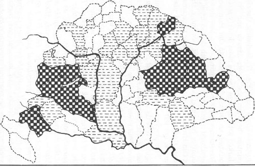
Fig. 27. Map showing the density of Hungary's population by the end of the Bronze Age (squares indicate the most densely settled areas).
3. The identity of the first settlers
The reader has no doubt noticed that most of the old place-names which were handed down by the first population of the Carpatho-Danubian area had some definite meaning in Hungarian. This fact suggests that they probably spoke Hungarian. This question shall now be analysed in more detail.
The archaeological remains of the epoch allow us to distinguish the presence of three closely related but different ethnic groups. The largest one was made up of farmers, usually referred to as Magari (Magyars) or Ari (Aryans). The second largest consisted of those engaged in animal husbandry, and were called Siculi, Sikeloi (Székely), while the third and smallest group were pastoralist people, an occupation frequently connected with the Kush. The following explanations support the threefold division, based upon the respective economic activity.
1. That the Danubian farmers were Aryans and first practised their trade all over Central Europe, was first noticed by L.A. Waddell, who stated that "the Aryans were the forerunners of the agricultural stage in the world's civilization" (P 132 p. 49). That these farmers were MagAri, or Magyars, appears from the analysis of the Magyar name itself, whose etymological meaning is, strictly speaking, 'farmer'. It was used, and still continues to be in that sense, both in Hungary and its neighbouring countries. In Hungarian, indeed, a 'farmstead' was Major (pron. Moyor), and in the Austro-Bavarian German dialect, the word for 'peasant' is similarly Mayer and Meyer. Farther west in Germany, however, the common word for the same term is 'Bauer'.
In addition to the semantic connection of 'agriculturist' with the Magyar name, there is much evidence suggesting that the bulk of the Neolithic and Bronze Age inhabitants were really Magyars. Such evidence includes the ethnic symbols, with which they identified themselves in pictorial writing. The most widely used ones were: (1) the bird (Madár), because it sounded like Magyar; (2) the lion, which was Magaru (= Magyar) in Sumerian-Hungarian; and (3) a bee (Méh), which combined with the wearer (Ur) formed the symbol Mehar, which also sounded like Magyar. The role of the first two symbols as Magyar ethnic identification badges was already discussed, therefore there is no need to return to this subject. For the use of the bee-symbol, however, we mention two instances: first, that the famous neolithic obsidian factory was operating in Hungary at Méh-Telek, i.e. on a 'Bee-Plot' and secondly that Herodotus records that in the Carpatho-Danubian region there are great multitudes of 'bees', so that it is impossible to visit that land (P 067 Book V cap. 10).
At this point we wish to introduce a unique statuette as well, found in a site of the neolithic Tisza-culture (Fig. 23). It represents the harvest divinity, holding a sickle in his right hand, an implement whose form is the wellknown abbreviation in the Hungarian carved script for Isten 'God'. The statuette in question belongs to the category of the so-called 'talking statues', because its posture coveys a message (P 074 p. 21). We can read it by naming its conspicuous elements one after another: the clenched hand (MArok), the arms in the plural KAR.ok, the face AR, and the belt RA. These elements identify the God as being Isten, MA-KAR.ok Ura 'God, Lord of the Magyars'. The ancient Egyptian kings, who were also considered earthly deputies for God, were frequently represented in exactly the same posture, as for instance King Ramses II, whose image is shown above (Fig. 22). The strong Egypto-Hungarian relations, which are apparent even here, do not surprise us for all three major Magyar ethnic symbols originated there. In ancient Egypt, the bird was the paramount divine symbol, the lion usually accompanied the royal image, while the bee in the royal cartouche was used to render the king's title as ruler of Lower Egypt. This suffices to conclude that the bulk of the first sedentary population of Old Hungary consisted of Hungarian-speaking, agricultural Magyars. These early settlers transplanted Egyptian agricultural know-how, tradition and mentality into the Middle Danube basin.
2. Hungary's next most numerous people of the Bronze Age, known by name, were the Siculi or Sikeloi inhabitants, whose descendants are called Székely (pron. Sakaly). They form a solid block of two and a half million Magyar-tongued inhabitants in the heart of Transylvania, the eastern province of historical Hungary. Their admirable folklore is their most characteristic ethnic feature and is fully permeated with the old solar cult. The visible image of their pre-Christian divinity, the Sundisc, is usually displayed in their coat of arms, together with the waxing Moon and the eight-pointed star. They are identical to those seen on ancient Mesopotamian documents. The Siculi believed their God was a human shaped giant, riding on a horse or in a brilliant chariot in the sky. All the words used by the Siculi in connection with the said idea-complex — Sun, Sky, Horse, Chariot, Way, Seat and so on — belong to the oldest layer of the Hungarian vocabulary. The etymological meaning of their name is also Hungarian, and corresponds to their intimate religious life. Sikeloi is, indeed, a compound with the following elements: S-IKE-LO-I, which would be spelt today Az Égi Ló-i, meaning 'Follower of the Celestial Horse' or, more plainly, 'Believer in Sungod'.
The Siculi or Sikeloi always played a significant part in Hungary's history. Prior to their alliance with Prince Arpad, they were allies of the Hun-Hungarians, in the Kingdom of Attila, according to our national Annals (P 120 I p. 101). They also took part in the decisive battle which brought about the downfall of the Hun Empire. Three thousand Siculi cavalry-men managed somehow to escape from the bloody battle and went into hiding in the unidentified Chigla-Field, waiting for the return of "other" Hungarians (usque ad aliorum Hungarorum reditum, P 120 I p. 279). As a matter of fact, when they found out, at the end of the IXth century, that a new Magyar group was on the way to Hungary under the leadership of Prince Arpad, the Siculi horsemen, who had been living in the land for a long time, galloped to the Carpathian passes to great their brethren. Then, according to their agreement, they helped unify the land into a single dominion. From that moment on, the fate of the Siculi merged with that of the Arpad Hungarians.
During the reign of King Attila, the bulk of the Siculi-Hungarians still dwelt in the western borders of the Carpathian land: in Upper Hungary and in Transdanubia. They were the stockbreeders of the epoch, belonging to a semi-military organization in charge of the defence of the western boundaries of the Hun Empire. They were directed by chiefs called Lófö, literally 'Great men', a title equivalent to the medieval marquis. After the Hun-era, when the disintegrated country was re-united by Prince Arpad and the Nation was converted to the Christian faith, the eastern borders of the land became the most sensitive ones. Therefore, the first Magyar kings transferred the Siculi frontier-guards from Upper Hungary into Transylvania for further duties. This displacement is evidenced by a series of medieval charters and more recently by a toponymic study showing that 36 village-names of Transylvania are the exact duplicate of as many Upper Hungarian place-names (Magyar Múlt, Sidney, 1977 no. 2). The Transdanubian Siculi, who were not involved in the massive transfer, remained in their original location in the West. Their long stay here explains the surprisingly high number of solar place-names, especially in Zala county, and also the existence of certain common dialectal particularities between the Transylvanian and the Transdanubian populations of today.
The fact that the Siculi's first places of habitation were in the western parts of historical Hungary, suggests that they may have entered into the land via the Adriatic Sea. The probability of this itinerary is dramatically confirmed by the presence of other Siculi on the western side of the Adriatic, namely on the Italian peninsula. This fact also suggests a simultaneous arrival into both lands in question, around the XIth century B.C. (cf. P 100 'Sicel'). That the Italian Siculi formed the integral part of the great Siculi migration is further evidenced by the fact that they too were led by chiefs called Syc-Lo-Pe and Laes-Turi-Gones, as reported by Thukydides in a distorted form (P 126 Book VI cap. 18). These terms would be, in the more correct spelling, Sikel Ló-Fö (after the P > F soundshift in Lo-Pe),meaning 'Siculi Great Men'; and Lovas Túri Honös 'Mounted Trojan Ancestor' respectively.(41) Another significant detail: one of the Siculi kings, Italus by name, became the namegiver of the whole Peninsula, and also of the present Italian nation.(42)
The Siculi in Italy were not numerous enough to keep the whole peninsula for themselves. Actually, they were driven out therefrom around 1035 B.C., when the majority of them crossed over to the island of Sicily and forced the earlier inhabitants to retreat into its western parts while they occupied all the rest of the land, changing its name to 'Sicilia'. They lived in peace on the island about three hundred years, until the Hellens began to drive them out. In the VIth century B.C., the Sicilians were defeated in battle and their separate national identity was gradually dissolved, — according to Thukydides.
Outside of Hungary and Italy, numerous Siculi tribes were also to be found in the northwestern Punjab (India). They were locally known as Sakai or Sakae (P 044 'Sakai'), the same as the Hungarian Székely. These Hindu-Sikeli were also followers of the Sungod, calling him Sacra (< Az Ég Ura) 'Lord of the Sky'. His female associate was Sacra Ni (H.: Sacra Neje) 'Wife of the Heavenly Lord'. All the Hindu Sikeli were engaged in animal husbandry. To sum up, the Siculi were a widely diffused ancient race of the Ilnd and 1st millen-iums B.C. One of their branches became, together with their Magyar brethren, the founders of European Hungary, as seen from an ethnic standpoint.
3. Traces of a third people are also discernible in the Neolithic and Bronze Ages in Hungary. They originated from the Kush or Cushan folk, usually referred to in the scientific language as Mediterraneans or Dinarians without, however, sufficiently emphasizing their characteristic brownish complexion. The Kush race was first identified in Eastern Africa, around the Great Lakes. It was also a widely diffused old race, but broken up into a multitude of smaller or larger ethnic entities that lacked any comprehensive political organisation for a long time. They were the first great historical people to send out colonists into southwest Asia and into Europe, including Hungary.
The European branch of the Kush seems to have spoken the Hungarian language: whether through origin or by assimilation, is not yet clear. At any rate, all their identifying symbols are Hungarian. The most widely used such symbol was the ram: it accompanied them through all their wanderings, in Egypt, Hungary, as well as in India and Touran. Ram in Hungarian is Kos (pron. Kush), which was also their national name. Their rulers, both terrestrial and divine, were called Fö-Kos, 'The Principal Kush', and his distinctive symbol was a kind of spontoon, called Fokos in Hungarian, a word that sounds like their name. Kristóf Lukácsy, a distinguished Hungarian historian of the XlXth century, was positively convinced that the language of the Kush was Hungarian, even while they were still sojourning in the Oxus region of Touran (P 092 p. 85).
The early presence of the Kush in Hungary is evidenced by a ram-headed altar found in a neolithic layer near Szeged. And the last notable group of them lived in Upper Hungary, during the reign of King St. Stephen (1000-1038). Their district was known as 'Dark Hungary' (Ungaria Nigra), as opposed to 'White Hungary' (Ungaria Alba), so called after the skin colour of the respective inhabitants. With the conversion to Christendom, the cohesive force of the Kush was broken and the people was absorbed into the majority. Their memory still lingers in such place-names as Kosd (< Kush-Ta), Kosna (< Kos Hona), Kustán (< Kus Tanya) and the family name of Kós.
To complete the presentation of the European Kush, we must also mention that classical and medieval historical sources inform us that both Britain and France have a considerable number of Kush absorbed in their national body, who were locally called Picti (P 132 pp. 111-126 and P 065 p. 394). The Romans believed that they were so called, because their faces were "painted", as the Latin word Pictus suggests. This view is, however, unacceptable because the Kush were already dark by birth and were called black well before the existence of the Latin language. The key to the solution lies in the Hungarian language, in which black is Fekete, whose old Hungarian form had been Pekete, Pekte, prior to the P > F soudshift. Consequently the oeiginal signification of the local name of the West European Kush simply meant 'dark' and not 'painted.' Another local name of the dark people in the British Isles was Cassi, from whom the Scots originated.
All the details listed above, when combined into a whole, are decisive proof that the earliest inhabitants of the Carpatho-Danubian area were Hungarians: variously known as agriculturist Magyars, stock-breeding Siculi-Székely, and darkish coloured pastoral Kush. In other words the present-day Hungarians seem to be direct descendants of the first inhabitants of the land who lived there four thousand years ago.
4. The testimony of the Tatárlaki (Tartaria) tablets
1. The first inhabitants of the Carpatho-Danubian area have bequeathed us with decisive historical evidence of their ethnic and linguistic identity, in three inscribed clay tablets found at Tatárlaki (now Tartaria), near the river Maros, in 1961 (Fig. 28). They turned up in a mound barely measuring 240 m X 100 m. One of the tablets is a roundel with a hole, while the two others are rectangular. The larger rectangular one also has a hole, but the smaller one only bears the picture of a horned goat. All three tablets appear to have been locally made, while the accompanying objects come from the Mediterranean and were either Cretan or Cycladic. The tablets aroused world-wide interest, because they gave scholars a concrete chance of identifying the language spoken by the earliest population of the Carpatho-Danubian basin.
Our inquiry about the tablets in question requires an answer to the following three questions: (1) for which purpose were the tablets made? (2) what message is written upon them? and (3) to which historical period do they belong? Amongst the multitude of studies already devoted to clearing up the mystery of these written documents found on the soil of ancient Hungary, the most valuable is that of Prof. M.S.F. Hood (USA) even though he failed to discover the purpose of the tablets and denied that there was actual writing in the signs carved upon the pieces.(43) Concerning the age of the tablets, there were two opinions. The first emphasizes the Mesopotamian character of the writing and, on that basis, suggests that the tablets may have been made in the Uruk-period, somewhere around 3000 B.C. The second opinion, that of Prof. Hood, insists upon their Cretan parallels and upon their Aegean and Anatolian connections in general. Accordingly, the holder of this second view assigns a considerably later period to the objects and suggests that they may have been made between 2000 B.C. and 1700 B.C. Since then, no new judgements have been formulated so that the mystery of the Tatárlaki tablets continues to remain unsolved, more than twenty years after their discovery.
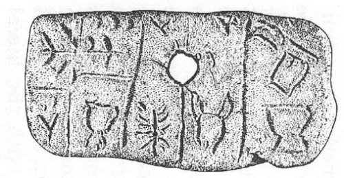
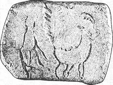
Fig. 28. The world-famous Tatárlaki (Tartaria) clay tablets, found near the river Maros. They were used for the purpose of solar observations.
2. In our procedure of trying to find the secret of the Tatárlaki tablets, we must first ascertain the purpose for which they were made. This inquiry begins with the etymology of Tatárlaki, the name of the village where they were discovered. It is a Hungarian compound, whose last element (-Laka) means a detached, small cottage, literally 'the dwelling of. But the first part of the name (Tatár) cannot be interpreted as having been the dwelling of some Tartarian person, because Tartars never lived in Hungary, particularly not in pre-Christian times. The full name in question is actually made up with the following elements: Tat-Ár-Lak-a, the vocalized form of an original deeper sounding Tót-Ur-Lak-a, with the literal meaning of 'God Thot's Cottage'. That makes sense, because God Thot was an important Egyptian divinity: patron of writing and reckoning, who was also in charge of measuring time and doing solar observations for the purpose of calendar making. In that perspective it seems logical to conjecture, that the Tatárlaki tablets themselves may have been used for solar observations and, ultimately, for setting up calendars.(44) This conclusion is supported by other, circumstantial evidence.
To begin with, the plot where the find was made is a small one, inadequate for farming. It was, however, large enough to make astronomical observations, especially during the summer. Then, the picture of a crab and a horned goat, engraved upon the tablets, is further evidence supporting this idea. The same animals, indeed, are part of the Zodiac, the crab being the symbol of the Cancer constellation, and the horned goat that of the Capricorn. Moreover, the circular hole appearing both on the roundel and upon the larger rectangle must have been connected with celestial observations, because this latter hole is surrounded by sunbeams to show, unequivocally, that the rising Sun is meant thereby. Finally, the most conspicuous details of the roundel supply us with the decisive word: Calendar. In fact, the circular hole represents the Sun, in Hungarian NAP, the giant cross intersecting the roundel carries the sound-value of T, and the circular rim of the object supplies the final constituent AR. These sounds, put together, give the word Nap-T-Ár, Naptár, which is the Hungarian word for 'Calendar'. It seems thus certain that the Tatárlaki tablets were components of a sophisticated solar observatory, and were used for determining time.(45)
3. Before proceeding to our next task, i.e. deciphering the script engraved upon the tablets, we must take a glimpse into the astronomical thinking of Antiquity. At that time, the Sun was considered a human-shaped divinity always on the move in the sky, following a fixed yearly path, during which it bypasses 12 important stations or groups of conspicuous stars called constellations. Several of these groups appear before the eyes of observers, as shaping celestial animals. Hence their names: Aries, Crab, Lion, Capricorn and so on. All together, these animals form the 'Animal belt' or Zodiac. The Zodiacal constellations were closely watched by ancient astronomers, because they were suitable phenomena for measuring time. Certain ones heralded the beginning of the seasons on a fixed day: Spring (March 21), Summer (June 22), Autumn (September 23) and Winter (December 22). In the northern hemisphere, the constellation that could be observed most easily, was the one which signaled the beginning of Summer. Daylight lasts longest on that day, when the Sun ceases to ascend higher on the horizon, and begins its downward course. This change of direction takes 11 days, during which the Sun rises every morning at the same time and on the same point of the horizon, as if it had stopped moving. So much suffices to understand the sense of the message upon the roundel, to which we now return.
The sound-signs appearing on the round tablet are, in our opinion, not Sumerian picture-signs, but more advanced carved signs. Most of them correspond to Old Hungarian writing signs (see Fig. 14). The only major difference the Tatárlaki tablets display vs. the Old Hungarian letters lies in their outward appearance: the Tatárlaki writing has a marked preference for linking signs together into bizarre geometric shapes. The very close resemblance of the Tatárlaki signs to the Old Hungarian ones invites us to try to read the mysterious message in Hungarian, beginning with the roundel, according to our Fig. 29, whereon the signs are separated into words.
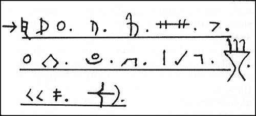
Fig. 29. The sound-signs of the Tatárlaki tablets, separated into words.
The first part of the message is placed in the upper half of the object in question. It reads from left to right and the signs are transliterated as follows: eZ. iR-áNY-O(n) J.öN eS.T.eN. 4. 05
Ó-Ra.K.oR. With present spelling: Ez irányon jön Isten 4.05 órakor, in literal translation: 'God comes (= the Sun rises) in this direction at 4:05 o'clock.' The second part of the message, inscribed on the lover half the roundel, reads in the reverse direction, from right to left, as is indicated by the so-called turning letters, specially N, R and K. It runs thus: ELE.RE aR.áK. S.iL.oK ég.ö-Ve.Be(n) 5 + 5 + eGY (= 11) É.Ta.K-áN, in present spelling: Előre a rák csillag égövében 11 éjszakán 'Beforehand the Crab is twinkling in its celestial zone for 11 nights.'
Is our reading reliable? It is, when considering the following. First, the decipherment produced a coherent and closely reasoned message, in which all the written signs appear with their own sound-value. This fact alone is usually considered as sufficient proof for the correct reading. Secondly, the message uses a highly technical language, according to the time and circumstances, which we can however understand, since we already know the fundamentals of ancient mentality. Besides, it follows the golden rule of the well written ancient inscriptions, inasmuch as it uses seven words — not less, nor more — in both sentences. Finally, all statements referred to in the inscription are accurate, and all have been confirmed, since then, by modern science. In fact, on the first day of Summer (June 22), the Sun rises at Tatárlaki, on the 46th parallel, exactly at five minutes past four o'clock.
Our next problem is to decipher the message inscribed upon the larger rectangular tablet. It is divided into three compartments. We are, alas, unable to make out the meaning of the signs placed into the first compartment; but the remaining part is clear enough and says: 'Here the Sun rises in the Cancer (constellation) on the day of...' (missing sign?).(46)
The smaller rectangle has no carved script scratched upon its surface, nor a hole to let the sunbeams penetrate into the observatory room. On its surface is a horned goat with an eleven-branched tail, symbol of the Capricorn constellation which announces the beginning of Winter. Behind the goat, the outlines of a roaring animal are discernible, probably that of the celestial dog, urging the Sun to ascend on its brilliant way again. That the goat's picture holds for the Sun, is evidenced by its having five legs, five being the sacred number of the solar divinity. To make a hole on this tablet would have been useless, because in winter the sky is usually overcast in Tatárlaki, and no astronomical observations can be made.
4. The last question in connection with the Tatárlaki tablets deals with the setting of the approximate date when the tablets could have been in use for solar observations. Prof. Hood approached this question by comparing the tablets with similar archaeological remains found at Knossos in Crete and concluded that the Tatárlaki tablets cannot be older than their Cretan variants, i.e. not older than c. 1900 B.C. Therefore, he added, if the solar equipment in question has been found in a neolithic layer, that could only have happened if the pit in which it was found had been dug from a higher archaeological level. Our own estimation, based upon the history of writing, supports the opinion of Prof. Hood all the more, because certain dating terms, such as "eleven times", appear on the similar Cretan tablets as well. Since, however, the writing on the Tatárlaki tablets is more mature, a younger age would be more suitable for them. This age can be determined through a mathematical operation, by converting the sidereal time given in the inscription, into our present time-computing system, taking into consideration the phenomenon of precession. This term designates the specific rotation of the Earth's axis which causes the beginning of the various seasons not to always occur in the same group of stars (constellation), nor on the same day. The vernal point actually advances upon the ecliptic at a rate of one day in every 72 years. Therefore, after a shift of 30 days, i.e. 2160 years (= 30 X 72), the sunrise will already occur in another constellation. The Tatárlaki tablets report that the Sun's descending course happened on the eleventh day of the Cancer constellation. On the other hand we also know that the Cancer constellation lasted from c. 2220 B.C. to c. 60 B.C. (P 118 p. 78). Thus, its approximative age results from the mathematical operation: B.C. 2220 minus 11 X 72, that is 1428 B.C.
As it disclosed, the Tatárlaki inscriptions constitute decisive historical evidence, whereby it becomes clear that the first permanent population of the Carpatho-Danubian basin spoke Hungarian and that their leaders had highly sophisticated knowledge. That Hungarians were in evidence in Central Europe considerably earlier than was theretofore believed, is a fact which obliges us to substantially modify our historical conceptions about the peoples of Europe in the Neolithic and Bronze Ages
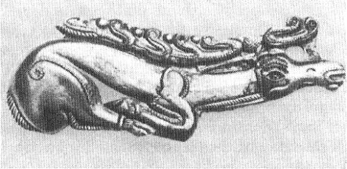
Fig. 30. The most beautiful Scythian gold-stag ever found in Hungary. Tápió-Szent-Márton, Vth century B.C.